
(Quaker-Hun-te’ EE Sun-Ke Was-we-kr)
By Red Hawk “Teerheer” aka Walt “Red Hawk” Brown, Chief, Cheroenhaka (Nottoway) Indian Tribe, Southampton County, Virginia
“May the Great Spirit guide your path in this walk of life, that you might make a difference in the walk of another.”
Edition One and Two,( 2004 and 2005), Of The Waskehee (WAS-KE-HEE)
Foreword
The Cheroenhaka (Nottoway) Indian Tribe made first “ethnohistoric” contact with the English (Colonials) in 1608-09.
“WE” were referred to as Mangoak, or Mengwe, by the Algonquian Tribes and later in 1650, per the dairy entries of James Edward Bland, referred to again by the Algonquian Tribes as “Na-da-wa” which reverted to” Nottoway” by the Colonials, and thus our derogatory name ”Nottoway” enters the annuals of Colonial History. In our native tongue, many words as recorded by Professor John Wood of W&M College in 1820, “WE” call ourselves Cheroenhaka (CHE-RO-EN-HA-KA and or Che-ro-ha-kah) – People At The Fork Of The Stream. WE lodged and hunted in the southeastern part of Virginia along the Nottoway and Blackwater Rivers as far as the Albemarle Sound.
“WE” were signers of three treaties with the English / Colonial Government: The Treaties of 1646, 1677 and February 27, 1713 (with Successor Clause); wherein, Tribal Land was granted, the last of which was the “Circle” and “Square” Tract” (41, 000 Acres) located in what is now Southampton and Sussex Counties. A Commonwealth of Virginia directed 1808 “Special Nottoway Indian Census ( Executive Papers of July 1-22, 1808),” as conducted by Henry Blow, William Blow (descendants of former Nottoway Indian Trustee John Blow), and Samuel Blunt, all ”Trustees” to the Nottoway Tribe of Indians, listed many, but not all, of the Cheroenhaka (Nottoway) Indian Tribal Members that were living on said “Reservations Lands” in Southampton County, Virginia in the vicinity of Assamoosick Swamp and Indian Town Road, Courtland, Virginia. Due to conditions germane to an influx of English Settlers (encroachment – a 1677 and 1713-14 Treaty violation ) and other ”forced” economic conditions; to include, “Documentary and/or Paper Genocide,” wherein, ones’ race was changed (paper wise), to reflect a heritage other than American Indian, along with, the sale of tribal lands, some of which (sales) were contrary to the “1790 Indian Non-Intercourse Act” requiring interaction / intervention by the Federal Government in all sales of land between Indians and Citizens within the Commonwealth of Virginia, some Cheroenhaka (Nottoway) Tribal Members dispersed to other locations outside of Southampton County and even the state of Virginia. However, the majority of our people remained and continued to live in communal groups as a tribe; such as, the one in “Artist Town,” consisting of the Artist, Bozeman, Turners, Browns, and Williams, from the 1850s up to the late 1980s and early 1990s, and their descendants (as of this day) still remain in Southampton County, Virginia and other surrounding counties as members of the “Historic” Reorganized Cheroenhaka (Nottoway) Indian Tribe.
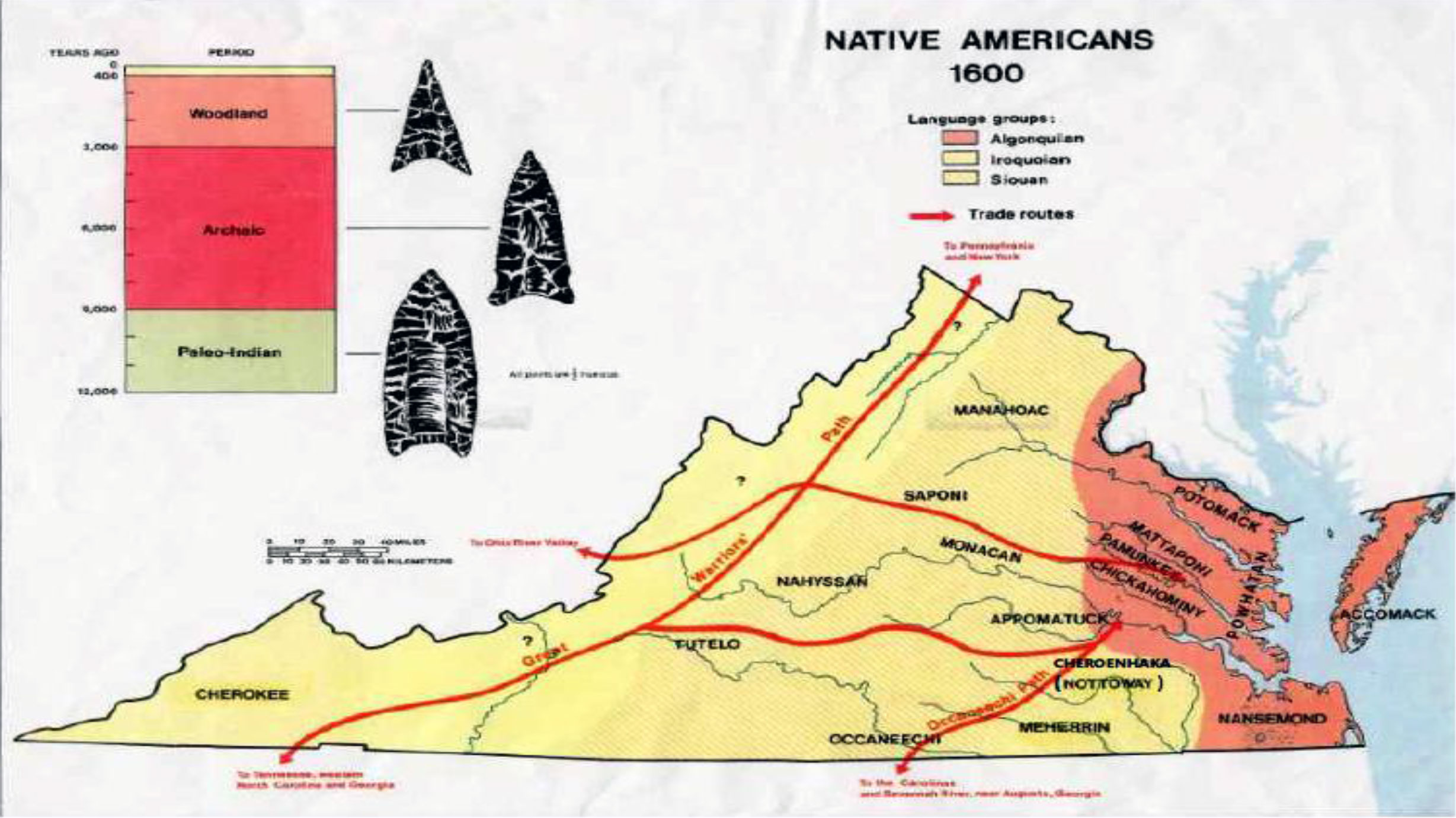
During the early seventeenth century, Iroquoian speaking tribes occupied lands east of the Fall Line on the Inner Costal Plain of southern (southeastern) Virginia and North Carolina. During this early period of contact those tribes consisted of the Cheroenhaka (Nottoway); the Meherrin and the Tuscarora – all of which belonged to the Iroquoian linguistic family. Although we spoke a similar dialect and shared cultures we were not always consistent political allies. Boyce (1978:282) states that: “The ethnic and territorial boundaries of the Iroquoian people are confusing but there are significant factors of their identities.”
My people, the Cheroenhaka (Nottoway) Indian Tribe have a richly “recorded” history within the Commonwealth of Virginia. “WE” first appeared in the ethno-historic record in 1608-1609 (James Mooney, estimated our population at 1,500 in 1600), when a group of Colonials from the Jamestown Colony traveled to what is now Nottoway County, Virginia to inquire about the fate of the Roanoke colony (Williams 1967:127). Upon arrival, their Powhatan Confederation’s guide(s) (Algonquian speakers) referred to the Cheroenhaka (Nottoway) as “Mangoak” or “Mengwe,” a derogatory name meaning stealthy, or treacherous, while we referred to ourselves as Cheroenhaka (CHE-RO-EN-HA-KA / CHERO-HA-KAH)), meaning “People At The Fork Of The Stream.” According to Floyd E. Painter, in his writing “The Last of the Nottoway,”(Archeological Society of Virginia, Quarterly Bulletin, Volume #15, June 1961, p.4) wrote, “ that most Indians were named by their neighboring Indians who came first in contact with the white man.” On a personal note, “WE” say, “ how can there be a last Cheroenhaka (Nottoway) Indian, as stated by Painter when referencing one William Lamb, when our blood still runs warm and thick and “WE” the Cheroenhaka (Nottoway) Indian descendants still walk our native land here in Southampton County, Virginia as members of the Historic (reorganized) Cheroenhaka (Nottoway) Indian Tribe.
Shortly after the treaty of 1646, which our ancestors signed with the Colonial government, and some forty years after the first recorded ethno-historic contact (1609), James Edward Bland and Abraham Wood, in 1650, got permission from Sir William Berkley, Governor of the Virginia Colony, to lead an exploration to the lands west of the Blackwater River. In Briceland’s reconstruction (1987:30) of the Bland-Woods’ journey, it infers that the Bland-Woods party, along with some “Algonquian speakers,” travel from what is now Petersburg Virginia in route to Weldon North Carolina. Along this route the Bland-Woods party passed within twenty miles of the Cheroenhaka (Nottoway) Indian village and burial ground (Quiocosine), currently referred to as the “Hand Site” in present day Southampton County, Virginia.
The Hand Site (44SN22), a late prehistoric site dated to ca. 1580-1640, is currently located off General Thomas Highway, six miles from present day Franklin, Virginia in Southampton County, in an area formerly known as Handsom, Virginia. The site lies on the western banks of the Nottoway River, approximately 8.5 to 9 miles above the Nottoway and Blackwater Rivers. Ethno-historic records (Archaeology of Eastern North America 26:133-162 (1998)), indicate that the “Hand Site,” settlement, which consisted of a palisade stockade surrounding a number of “Long Houses” and cemetery (Quiocosine House), was occupied by Iroquoian groups, specifically the Cheroenhaka (Nottoway) Indians. In 1963, 1966 and 1969 excavations were undertaken at the “Hand Site” and 131 separate individual grave remains of Cheroenhaka (Nottoway) Indians were removed and placed on a shelf at the National Museum of Natural History, Smithsonian Institution, Washington, DC. Said remains were accessioned into the Physical Anthropology collections – “WE” say, it is now time for our ancestors to come home.” It is noted that the “Hand Site” falls under Executive Order No. 13007, dated May 24, 1996 as an Indian Sacred Site.
The route that Bland-Woods traveled in 1650 also took them through other Cheroenhaka (Nottoway) Indian Tribal territory. The first Cheroenhaka (Nottoway) Indian Village they encountered was two miles west of the Nottoway River, near what is now Homeville, Virginia, located near the intersection of Highway 35 and Highway 40 in Sussex County, Virginia. A second Cheroenhaka (Nottoway) Indian Village was discovered near present day Drewryville, Virginia, in Southampton, County, off Highway 58, near the present day towns of Capron and Emporia Virginia. It is noted that another of our Quiocosine House(s), (Burial Grounds), is currently located in Drewryville Virginia. This evidence promulgates that our people, the Cheroenhaka (Nottoway) Indian Tribe, in the mid-seventeen century were living in the upper reaches of the Nottoway River, where the Nottoway and Blackwater rivers join to form the Chowan River – thus “WE” glean our garner name “People At The Fork Of The Stream” – CHEROENHAKA (CHE-RO-EN-HA-KA).
Based on accounts by Bland (Bland Papers), his party encountered a young (“a youth”) Cheroenhaka (Nottoway) werrowance (leader). The Algonquian speakers traveling with Bland referred to the Cheroenhaka (Nottoway) Indian as “Nadawa,” (Na-da-wa), a derogatory name meaning snakes, adder, enemy – thus the name “Nottoway” enters into the annals of Colonial history. At this time of European contact, Lewis R. Binford wrote that the Cheroenhaka (Nottoway) Indians consisted of some 500 people. (Binford 1961: 140-141). Binford further infers that “hereditary positions” structured the Cheroenhaka (Nottoway) Tribal social organizations – the Nottoway were a simple Chiefdom or Kingdom. In 1669 and act of the General Assembly (A Special Census), specified the number of warriors or “Bow Men” in the various neighboring tribes. Binford writes that the Cheroenhaka (Nottoway) Indians, from the special census of 1669, can be estimated as having some 90 fighting men – a rough approximation of Indians can be obtained by calculating ten persons for each 3 fighting men, yielding a population of some 300 Cheroenhaka (Nottoway) Indians. (Binford 1967: 151-152.
Our ethno-historic record is also intertwined with the infamous Nathaniel Bacon’s Rebellion of May 1676 (Bacon’s Rebellion; Wm. and Mary Quarterly Historical Magazine Vol. IX, July 1900, No. 1). Bacon originally tried to induce support from the nearby Tributary Indians (Algonquian Speakers) to fight what he considered a common enemy (the Susquehanna Indians) that were moving southward toward what was Charles City, (now Prince George); however, they would not join him because of orders received to the contrary from Governor Berkeley. Bacon, knowing that the Susquehanna Indians would try to combine with, and /or buy powder from the Occaneechee Indians, known a great traders of goods, who lived on an island on the Roanoke River, directed his march in that direction. As a result of not being able to add to his force of volunteers of some 187 men, Bacon turned southward to get assistance of the “Nottowaies” (Cheroenhaka (Nottoway) Indians) and the “Mayherings” (Meherrins). Upon departing, some 24 Cheroenhaka (Nottoway) and Meherrin Warriors accompanied him to the downfall of Ocaneechee Island on the Roanoke River.
The Cheroenhaka (Nottoway) –“We” – were signatory to the Woodland Plantation Treaty of 1677. Our former Tribal “Teerheer’s” (Chief) sign bears the mark of “three-rivers” on said treaty. Land that originally belonged to us was now supposedly given by the Colonial Council of the Commonwealth of Virginia, with promises that encroachment would not occur by incoming Colonial Settlers within a three miles radius of our tribal reservation lands. “WE” could now keep our lands, then situated in what is now the communities of Stony Creek (Nottoway Town of “Tamahittion”) and Jarratt, Virginia. However, with the opening of the lands south of the Blackwater for settlement by the English, the treaty promise was negated. As a result of continual encroachment by the English, and to avoid war with other tribes, the Cheroenhaka (Nottoway) Indians’ moved a final time to a reservation site at the mouth of the Assamoosick Swamp covering present day Courtland and Sebrell, Virginia. In 1705 the House of Burgesses granted us two tracks of land – the “Circle” and “Square” Tract consisting of some 41, 000 acres of land. These tracts of land fell within the confines of what was then Isle of Wight County – now Southampton and Sussex Counties. It is noted that Southampton County was annexed from Isle of Wight County in 1749-50.
In 1711, Colonial Lieutenant Governor Alexander Spotswood, along with 1600 armed men, visited the Cheroenhaka (Nottoway) Indian Reservation. He met with the “Teerheer” (Chief) of the Nottoway Nation whose name was Occuraass (often referred to as “William Edmund” by the Colonials). The purpose of Spotswood’s visit was to ensure that the Cheroenhaka (Nottoway) Indians did not join forces with the warring Tuscaroras Indians and to get the Chief Men to send their sons to the “Brafferton,” a school for Indians at William and Mary College (Karen Stuart, “So Good A Work,” The Brafferton School, 1691-1777). The Nottoway were fearful that their sons would be sold into slavery. As evidence of his good faith, Spotswood, offered to remit the annual treaty tribute due from the Cheroenhaka (Nottoway) Indian Tribe, in exchange for the promise to send two of the Chief Men’s sons to the “Brafferton.” Ethnohistoric records reveal that by November 17, 1711, Spotswood reported that two sons of the Cheroenhaka (Nottoway) Chief Men were attending the College. It is noted that Cheroenhaka (Nottoway) Indian surnames continued to appear on the enrollment roster of the “Brafferton” throughout the 1750s and 1760s.
In 1713-14 upon the conclusion of the Tuscarora’s war, three separate treaties were made and signed under the watch of Spotswood – the Sapony, the Tuscarora and the Cheroenhaka (Nottoway). Of special note, It is the understanding of the Cheroenhaka (Nottoway) Indian Tribe, in that our Treaty of February 27, 1713 has never been negated by the Federal Government, nor made null and void by a court of law; as such, we still have a continuing “recognized” relationship with the Commonwealth of Virginia.
In the years preceding the signing of the Treaty of 1677 (Middle Plantation) the Cheroenhaka (Nottoway) Indians, one of two Iroquoian groups, as reported on the 1669 Indian Census as numbering about 1500 strong (McCary 1957:78). Some forty-five years later and prior to the signing of the Cheroenhaka (Nottoway) Indian Tribe’s “Stand Alone” treaty of 1713 between the Chief, Occuraass Teerheer, [called William Edmund by the Colonials…WDB], and Colonial Lieutenant Governor Alexander Spotswood, Beverly estimates a population of 330 Nottoways in 1705. Historian attribute this rapid loss of population to wars with the Colonials (English), wars with enemy tribes, smallpox and other diseases. The greatest of all diseases was land encroachment by the English which negated freedom of movement to hunt, fish, and for a people to live according to their inherited traditions and culture.
It is noted that the Middle Plantation Treaty which was signed on May 29, 1677, at the Capital in Williamsburg, Virginia, between the Virginia Indian Tribes and the Colonial Governor Herbert Jeffreys included the mark (three rivers) of the King of the Cheroenhaka (Nottoway) Tribe whose name was Serrahoque (Ser-rah –o-que). (Sasser, thesis, p.146). According to Sasser’s thesis, all the Kings of the Tribes, who now were tributary Indians, were sent coronets with false stones. Serrahoque, King of the Cheroenhaka (Nottoway) Tribe, received a Crown and a Purple Robe.
The terms of the treaty of 1677 had specified pledges/agreements from the Indians and the Colonials. By the mark of Serrahoque, (three rivers), the Cheroenhaka (Nottoway) People agreed to the following: 1. Acknowledge dependence on and subjection to the King of England; 2. to let the colonists know of any hostile activity by non tributary or foreign Indians; 3. to serve with the Colonial Military of times of war or danger; 4. to submit all inter and intra tribal disputes to the colonial government for resolution; 5. to pay a tribute of 3 arrows for the land, and 20 beaver skins for protection annually on King George’s Day (March 23), thereby becoming “tributary Indians.” (Robinson, Early Am. Ind. Docu. 4: 82-87). Some historians state that the “Nine Indian Nations” of Virginia, which included the Nottoway Nation, were tributary by the fact that they paid tribute to the Colonials / colony (Brown 1968: 7).
By the treaty of 1677, the English agreed to the following: 1. the Indians were to have their land confirmed to them by the government of England [Note: the land already belonged to the Cheroenhaka (Nottoway) Indians – how can a government confirmed what is already yours?…WDB]; 2. their persons and goods were to be secured and protected by the crown; 3. they were to received equal justice and treatment under the Colonial Law [Note: this clause violated the Cheroenhaka (Nottoway) Indian Tribe’s right to self govern themselves as one of the recognized “Nine Indian Nations of Virginia…WDB]; 4. the Indian Kings, (Serrahoque and his “Great Men”), were not to be imprisoned without special consent of the Governor; 5. they were to have protection from being sold into slavery [Note: ethnohostoric records reveals that some of the Cheroenhaka (Nottoway) Indian Children were enslaved. It is further noted in accordance with Jones, Dinwiddle, p. 43 that in 1682 Indian Slavery existed among captives sold by tributary tribes and was abolished fifteen years later in 1691…WDB]; 6. the Cheroenhaka (Nottoway) People were to have the right to gather wild plants and utilized the waterways [Note: the Nottoway, Blackwater and Chowan Rivers were used extensively by the Nottoways…WDB] for travel and sustenance. ( Binford 1964: 192-93).
After the treaty of 1677 land encroachment continue with the opening of the lands along the Blackwater River. Large land sections were seized by the Colonials on the south side of the Blackwater. In 1690 an order was levied by the Colonial Council to suspend further surveys in theses lands deemed as lodging and hunting territories of the Indians; however, the question of acquiring lands along the Blackwater would stir among the Colonial Council for the next twenty years ( Lutz 1957: 47). As land encroachment intensified by the Colonial, who moved out from the James River into the territory occupied by my people, and by the 18th century had surrounded us, forced an abandonment of our villages in the 1680s at Tonnatorah (Ton-na-to-rah) and Rowantee (Ro-wan-tee) along the Nottoway River in what is now Sussex County (Boyce 1978: 286 and Sasser, thesis, p. 33). We moved from our villages on the “Fall Line,” which had become the Tuscarora Trading Path, Southeast, along the Nottoway River and settled in the area of the Assamoosick (As-sa-moo-sick) Swamp and settle a “Great Town” in what is now Sussex and Southampton Counties. [Note: this is the place that is referred to as “Old Town” in historical documents. It is also noted that Assamoosick in our native tongue (Dasunke) means “ stream that does not run dry”…WDB] (Report of Thomas Wynn of Prince George County in 1707). In 1694/95 the Cheroenhaka (Nottoway) Indian Tribe was compelled by attacks from hostile tribes to move a third time. This move was more Southward to the mouth of the Assamoosick Swamp in what is now the Southampton County Virginia towns of Sebrell and Courtland. (Parramore 1978: 4).
In 1711, Colonial Lieutenant Governor Alexander Spotswood, along with 1600 armed men, visited the Cheroenhaka (Nottoway) Indian Reservation at the mouth of the Assamoosick Swamp in what is now Courtland, Virginia. He met with the “Teerheer” (Chief) of the Nottoway Nation whose name was Occuraass (often referred to as “William Edmund” by the Colonials). The purpose of Spotswood’s visit was to ensure that the Cheroenhaka (Nottoway) Indians did not join forces with the warring Tuscaroras Indians and to get the Chief Men to send their sons to the “Brafferton,” a school for Indians at William and Mary College (Karen Stuart, “So Good A Work,” The Brafferton School, 1691-1777). The Nottoway were fearful that their sons would be sold into slavery. As evidence of his good faith, Spotswood, offered to remit the annual treaty tribute due from the Cheroenhaka (Nottoway) Indian Tribe, in exchange for the promise to send two of the Chief Men’s sons to the “Brafferton.” Ethnohistoric records reveal that by November 17, 1711, Spotswood reported that two sons of the Cheroenhaka (Nottoway) Chief Men were attending the College. It is noted that Cheroenhaka (Nottoway) Indian surnames continued to appear on the enrollment roster of the “Brafferton” throughout the 1750s and 1760s.
On February 27, 1713 upon the conclusion of the Tuscaroras War with the English, a “Stand Alone Treaty” was signed between the Cheroenhaka (Nottoway) Indian Tribe and Colonial LT. Governor Alexander Spotswood. In accordance with our documented and oral history we understand that our Treaty of 1713 has never been negated by the Commonwealth of Virginia, nor the Federal Government, nor made null and void by a court of law; as such, we still have a continuing “recognized” relationship with the Commonwealth of Virginia.
Ethnohistoric documents records Spotswood’s Treaty with the Nottoways, which was signed on February 27, 1713 and read on September 9, 1714 as follows:
Document 32
Spotswood’s Treaty with Nottoways
[ P.R.O., C.O. 5:1316, 609-616 (transcripts)] 38
=========================================
[ Feb. 27, 1713]
Treaty of Peace made and concluded on the one part by the Honorable Alexander Spotswood her Majesties Lieutenant Governor and Commander in chief of the Colony and Dominion of Virginia for and in behalf of the said Colony And on ‘the other part by Ouracoorass Teerheer of the Nottoway [Note: true name of he Nottoway is Cheroenhaka….W.D.B.], Indians in behalf of the said Nation.
Done and Signed at Williamsburg the 27th of February 1713
Whereas the Lands Laid our and appropriated for the Settlements of the Nottoway Indians in pursuance of he articles of peace made at Middle Plantation the 29th day of May 1677 being now encompassed by the Latter Settlements of the English Inhabitants are thereby become inconvenient for the hunting by which the said Indians Subsist, in regard, that being obliged to pass through the plantations of the English quarrels do often arise to the interruption of good correspondence between her Majesties Subjects and the said Nation of Indians, Whereupon the Teerheer [Note: King and/or Chief…W.D.B.] of said Nation having intimated his desire to change his present settlement for one more remote from the English as well for avoiding all occasions of difference with the Inhabitants as for the convenience of a larger Range for hunting. The Governor of Virginia being desirous to grant so reasonable a request and at the same time to employ the Service of the said Nation of Indians (of whose fidelity he hath had Several proofs) for the protection of her Majesty’s Subjects inhabiting the Frontiers of this Colony, and willing also toe lay hold of this opportunity to improve the favorable disposition of the said Nation towards embracing the Christian Faith by which means the Glory of God may be promoted, and the fidelity of the said Indians Secured by the Stricter Ties of Religion, Hath therefore by and with the advice of her Majesty’s Council concluded this present Treaty as follows:
I.
The Said Nation of Indians shall from henceforth continue Tributary’s to her Majesty of Great Britain and her Successors under the Subjection of the Government of Virginia.
II.
The said Indians do Consent and promise that as soon as a Tract of Land shall be allotted them for their habitation and a School Master and Minister established among them all their children and also the Children of any other Nation of Indians who shall Incorporate with them shall be taught the English Language, and Instructed in the principles of the Christian Religion and in the mean time shall send twelve boys to be educated as the Saponee Town, whenever a school master shall be established there. [Note: On August 13th, 1715, after three days in irons and chains, the Chief and Great Men (8 each) of the Nottoway Indians, consented to send 12 boys to Fort Christiana…Saponee Town…(Vol. III, Executive Journals of the Council of Colonial Virginia, pg. 408)…W.D.B.].
III.
The said Indians shall be faithful to her Majesties Government of Virginia and maintain a Strict Peace, friendship and amity with all her Majesties Subjects of the said Colony: and on the other hand of any Controversies shall arise between the inhabitants of the said Colony and the said Indians, Justice shall be done to both parties according to the Laws of the said Colony neither shall it be Lawful for either party to seed redress by any other means.
IV.
If the said Indians shall at any time discover an Conspiracy carried on by any of their own or other Nation of Tributary Indians against the inhabitants of Virginia, or any of the other Indians Tributaries thereto, or that any strange Indians are on their march to attack said Colony or it’s Tributaries, the said Indians shall give immediate notice thereof to the Governor for the time being, and shall be ready with all their Force to suppress such Conspiracy or foreign Invasion, either by themselves or in Conjunction with the Forces of the said Colony. And if any murders or thefts shall be committed by any Indians whatsoever upon the English, The said nation of Indians do promise to use their best endeavors to apprehend the offenders and deliver them up to be punished according to the Laws of Virginia. And it is further stipulated that the said Indians shall hold no correspondence with any foreign Indians whatsoever without Lycense [License] of the Governor of this Colony for the time being.
V.
There shall be set out and assigned for the Settlement of the said Nation and all other Indians who shall hereafter incorporate with them a tract of Land between the Rivers of Appomattox and Roanoke above the inhabitants, equivalent to Six miles Square where they may build a Fort and make improvements for the convenience and Subsistence of their families: And moreover there shall be set apart a sufficient tract of hunting Grounds for the said Indians between Roanoke and James Rivers to be bounded in such manner as the Governor shall think fit, And if it should happen that the lands in those parts be at any time hereafter taken up and patented by her Majesties Subjects as high as the present intended settlement of the said Indians, so as it may thereby become necessary to remove the said Indians to a further distance, a tract of the like quantity of Land shall be of new laid out and assigned for the habitation and sufficient satisfaction and made for such Improvements as they shall leave behind them, But the said Indians shall not Sell or alienate any part of the Lands so to be assigned them; The Same being hereby intended to remain in Common to them and their Posterity. And all Sales or Leases thereof made by them to any English man upon what consideration so ever are herby declared to be contrary to this Treaty, Nevertheless it is hereby Concluded and agreed that there may be set apart by the Governor of Virginia out of the lands assigned, form time to time for the habitation of the said Indians, a tract not exceeding two thousands acres, for the better Support of the Minister and School Master to be establish there, and of the officer and men to be appointed for the Guard of the said Indian Fort, which tract shall in like manner remain for the use of said Minister, School Master, officer and men according to the distribution thereof to be made for each respectively by the Governor of Virginia without being subject to the alienation mortgage or Lease of any of the persons in those employments Provided always, that if though mortality or Desertion the said Nation of Indians shall decrease to an inconsiderable number no greater tract of Land shall be required of them for their habitation that according to the proportion of one hundred acres for each person, with the liberty of hunting on all the un-patented Lands between the said Rivers as aforesaid.
VI.
For the better defense of the said Indian Settlement there shall be maintained as the public charge of the Government of Virginia an officer and twelve men, to reside in their Fort so long as It shall be found necessary to assist them against any strange Indians by whom they may be attacked and to go out with them hunting as there shall be occasion.
VII.
During the continuance of the aforesaid Officer and men at the said Indian Fort none of the said Indians shall depart off the grounds allotted for their habitation nor repair to the Towns of the other Tributary Indians except in company with some of the English residing at their Fort, neither shall any of the said Indians depart off their hunting grounds or come among the Inhabitants without the License of the Governor or the Capt of the Fort, or in Company with some English men belonging to the said Fort on pain of being punished at the Governor’s discretion, Nor shall it be permitted them to hunt on the land of any other Tributary Indians without the leave of Such Tributaries.
VIII.
For the convenience of the said Indians and for the more regular carrying on the trade, there shall be a public Mart or Fair kept at their Settlement, at lest Six times in a year, where it shall be free for all her Majesties Subjects to resort with their wares and merchandizes, and to exchange the same with the Indians for their skins, Furs and other Commodities; and Magistrates shall be appointed to attend as the said fairs to see the trade justly managed to enquire into any abuses or injuries offered to the Indians by any of the English residing among them and to administer justice in all Controversies that may arise between either party, concerning the same.
IX.
The articles of peace made and concluded with the said Nottoway Indians at Middle Plantation the 29th day of May 1677, so far as the same are altered by this present Treaty, are hereby ratified and Confirmed and shall be construed to extend to all the Indians who shall hereafter incorporate with the said Nottoways.
X.
If any Infringements be made of this present Treaty by any of her Majesty’s Subjects within the Colony of Virginia; upon a representation thereof made by the said Indians; Due reparation and satisfaction shall be given them therein.
XI.
Whereas the Governor of Virginia some years ago, in order to encourage the said Indians to send some of their Children [ Note: the Chief Men’s Sons,…Spotswood’s’ letters reporting two Nottoway male children attending the Brafferton ( School for Indians at William & Mary College) in 1711…W.D.B.] to be educated at the College of William and Mary, remit the annual Tribute of Skins which were payable by the said Indians to the Governor for the time being; And it being Stipulated by the first article of this present Treaty that the said Indians shall continue Tributary’s, without mentioning the quality or proportions there to be paid by them, The said Governor being still desirous to encourage and promote the Conversion of the said Indians and by easing them in the said tribute to engage them the more to a faithful observance to this present Treaty, Doth hereby Stipulate and agree with the said Indians that the said Nation shall only pay as an acknowledgement of their dependence on the Crown of Great Britain the yearly Tribute of three Indian arrows [Note: The Nottoway Indian Nation’s dependence upon Great Britain(62 years) ended in 1775 (A total of ‘‘186 Arrows” delivered,“ 3ea per year)…Revolutionary War 1776…W.D.B.], to be delivered by the Chief men of the said Nation to the Governor or Commander in Chief of Virginia for the time being yearly on St. George’s day at the Palace in Williamsburg. [Note: St. George’s Day celebrated on April 23…W.D.B.]
The mark of
Ouracoo  rass
rass
Teerheer of Nottoway
(Endorsed Virginia/Treaty with the Nottoway/Indians Concluded at/Williamsburg the 27th/February 1713/referred to in Coll/Spotswood’s Lre of /9th March 1713./Received 1 Septr/Read Sept. 9th, 1714/O:163/Entered F folio 56)
[Transcribed By: Chief Walt “Red Hawk” Brown, Teerheer, Cheroenhaka (Nottoway) Indian Tribe…2/02/2005]
…………..(To be continued in our next edition, Issue Three 2006, of the “WASKEHEE’ (WAS-KE-HEE) – To See).
“To be remembered in history by such a derogatory name “Nottoway” given to us by the Algonquians speakers, of the coastal regions, pains our hearts – for we are Cheroenhaka, “People At The Fork Of The Stream” and our history must be made right. WE walk this sacred circle of life, in hope that our walk will make better the walk of another. Those that will come after us, who will walk the inner circle life – our children.”
~~~
Waskehee, Issue Three
(Continued From The Second Edition – Issue Three 2006, Of The Waskehee (WAS-KE-HEE)
February 27, 1713 marked the conclusion of the Tuscaroras war, with the signing of three separate treaties made and signed under the watch of LT Governor Alexandria Spotswood – the Sapony, the Tuscarora and the Cheroenhaka (Nottoway). Of special note, It is the understanding of the Cheroenhaka (Nottoway) Indian Tribe, in that our Treaty of February 27, 1713 has never been negated by the Federal Government, nor made null and void by a court of law; as such, we still have a continuing “recognized” relationship with the Commonwealth of Virginia.
In the years following the signing of the Treaty of 1713, the Colonials directed their attention to the chore of establishing a dividing line between Virginia and North Carolina. William Byrd II of Westover was instrumental in recording this history. The history is recorded in the Westover manuscripts, 1674 – 1744. Of particular interest to this author are the diary entries that Byrd made upon visiting one of the Cheroenhaka (Nottoway) Indian Towns on April 7, 1728. Here he describes the hospitality, nature, lodging and appearance of the Cheroenhaka (Nottoway) Indian women and men as depicted in the following extracts taken from the Westover manuscripts germane to the history of the dividing line between Virginia and North Carolina, a journey to the land of Eden, A.D. 1733, and a progress to the mines written from 1728 to 1736 Petersburg, Virginia: Printed by Edmund and Julian C. Ruffin, 1841:
History of the Dividing Line: Run in the Year 1728
April 7th, 1728: In the morning we dispatched a runner to the Nottoway town, to let the Indians know we intended them a visit that evening, and our honest landlord was so kind as to be our pilot thither, being about four miles from his house. Accordingly in the afternoon we marched in good order to the town, where the female scouts, stationed on an eminence for that purpose, had no sooner spied us, but they gave notice of our approach to their fellow citizens by continual whoops and cries,…….. This signal assembled all their great men, who received us in a body, and conducted us into the fort. This fort was a square piece of ground, enclosed with substantial puncheons, or strong palisades, about ten feet high, and leaning a little outwards, to make scaling more difficult. Each side of the square might be about a hundred yards long, with loop-holes at proper distances, through which they may fire upon the enemy. Within this enclosure we found bark cabins sufficient to lodge all their people, in case they should be obliged to retire thither. These cabins are no other but close arbors made of saplings, arched at the top, and covered so well with bark as to be proof against all weather. The fire is made in the middle, according to the Hibernian fashion, the smoke whereof finds no other vent but at the door, and so keeps the whole family warm, at the expense both of their eyes and complexion. The Indians have no standing furniture in their cabins but hurdles to repose their persons upon, which they cover with mats and deer-skins. We were conducted to the best apartments in the fort, which just before had been made ready for our reception, and adorned with new mats, that were very sweet and clean. The young men had painted themselves in a hideous manner, not so much for ornament as terror. In that frightful equipage they entertained us with sundry war dances, wherein they endeavored to look as formidable as possible. The instrument they danced to was an Indian drum…… a large gourd with a skin braced tight over the mouth of it. The dancers all sang to the music, keeping exact time with their feet, while their heads and arms were screwed into a thousand menacing postures. Upon this occasion the ladies had arrayed themselves in all their finery. They were wrapped in their red and blue match coats, thrown so negligently about them, that their mahogany skins appeared in several parts, like the……. damsels of old. Their hair was braided with white and blue peak, and hung gracefully in a large roll upon their shoulders. 182.
This peak consists of small cylinders cut out of a conch shell, drilled through and strung like beads. It serves them both for money and jewels, the blue being of much greater value than the white,…… The women wear necklaces and bracelets of these precious materials, when they have a mind to appear lovely. Though their complexions be a little sad-colored, yet their shapes are very strait and well proportioned. Their faces are seldom handsome, yet they have an air of innocence and bashfulness, that with a little less dirt would not fail to make them desirable. Such charms might have had their full effect upon men who had been so long deprived of female conversation, but that the whole winter’s soil was so crusted on the skins of those dark angels, that it required a very strong appetite to approach them. The bear’s oil, with which they anoint their persons all over, makes their skins soft, and at the same time protects them from every species of vermin that use to be troublesome to other uncleanly people. We were unluckily so many, that they could not well make us the compliment of bed-fellows, according to the Indian rules of hospitality, though a grave matron whispered one of the commissioners very civilly in the ear, that if her daughter had been but one year older, she should have been at his devotion.183.
It is by no means a loss of reputation among the Indians, for damsels that are single to have intrigues with the men; on the contrary, they account it an argument of superior merit to be liked by a great number of gallants. However, like the ladies that game, they are a little mercenary in their amours, and seldom bestow their favors out of stark love and kindness. But after these women have once appropriated their charms by marriage, they are from thenceforth faithful to their vows, and will hardly ever be tempted by an agreeable gallant, or be provoked by a brutal or even by a careless husband to go astray. The little work that is done among the Indians is done by the poor women, while the men are quite idle, or at most employed only in the gentlemanly diversions of hunting and fishing. In this, as well as in their wars, they use nothing but fire-arms, which they purchase of the English for skins. Bows and arrows are grown into disuse, except only amongst their boys. Nor is it ill policy, but on the contrary very prudent, thus to furnish the Indians with fire-arms, because it makes them depend entirely upon the English, not only for their trade, but even for their subsistence………. We put the Indians to no expense, but only of a little corn for our horses, for which in gratitude we cheered their hearts with what rum we had left, which they love better than they do their wives and children……..184.
The whole number of people belonging to the Nottoway town, if you include women and children, amount to about two hundred. These are the only Indians of any consequence now remaining within the limits of Virginia. The rest are either removed, or dwindled to a very inconsiderable number, either by destroying one another, or else by the small-pox and other diseases. Though nothing has been so fatal to them as their ungovernable passion for rum, with which, I am sorry to say it, they have been but too liberally supplied by the English that live near them……… Many children of our neighboring Indians have been brought up in the college of William and Mary. They have been taught to read and write, and have been carefully instructed in the principles of the Christian religion, till they came to be men….. 185.
And some of them too have made the worst use of the knowledge they acquired among the English, by employing it against their benefactors. Besides, as they unhappily forget all the good they learn, and remember the ill, they are apt to be more vicious and disorderly than the rest of their countrymen……. At that critical time it was thought expedient to keep a watchful eye upon our tributary savages, who we knew had nothing to keep them to their duty but their fears. Then it was that he (Spotswood) demanded of each nation a competent number of their great men’s children to be sent to the college, where they served as so many hostages for the good behavior of the rest……..as I hinted before, that there is but one way of converting these poor infidels, and reclaiming them from barbarity, and that is, charitably to intermarry with them, according to the modern policy of the most Christian king in Canada and Louisiana. Had the English done this at the first settlement of the colony, the infidelity of the Indians had been worn out at this day, with their dark complexions……… All nations of men have the same natural dignity, and we all know that very bright talents may be lodged under a very dark skin. The principal difference between one people and another proceeds only from the different opportunities of improvement. The Indians by no means want understanding, and are in their figure tall and well-proportioned. Even their copper-colored complexion would admit of blanching, if not in the first, at the farthest in the second generation. I may safely venture to say, the Indian women would have made altogether as honest wives for the first planters………187.
April 8th, 1728: We rested on our clean mats very comfortably, though alone, and the next morning went to the toilet of some of the Indian ladies, where, what with the charms of their persons and the smoke of their apartments, we were almost blinded. They offered to give us silk-grass baskets of their own making, which we modestly refused, knowing that an Indian present, like that of a nun, is a liberality put out to interest, and a bribe placed to the greatest advantage. Our chaplain observed with concern, that the ruffles of some of our fellow travelers were a little discolored with pochoon, wherewith the good man had been told those ladies used to improve their invisible charms.188. ..….(To be continued in our next edition, Issue Four 2007, of the “WASKEHEE’ (WAS-KE-HEE) – To See).
Waskehee, Issue Four
(Continued From The Third Editiion – Issue four 2007 of The Waskehee (Was-Ke-Hee) – To See)
ISSUE IV – 2007
Shortly after Byrd’s visit to the Cheroenhaka (Nottoway) Indian’s Towns in 1728 and as a result of continual encroachment by other Colonials, who had an interest in ownership of our tribal lands, we continued to remain aloof. Remembering our plight over the years, in an effort to remain at a distant from the colonials and other warring tribes, we relocated our tribal villages a number of times beginning in what is now Nottoway County, to Sussex County, then to Surry County, Isle of Wight County and now, since 1749, here in Southampton County. Even thought we vacated our lands in these counties, we remember those we left behind in the place we call QUIOCOSINE (QUI-0-CO-SI-NE), House or Place of Burial.
Within the confines of our native lands, the Circle and Square Tract, as granted by the House of Burgess in 1705, there are four Quiocosine (Qui-o-co-si-ne) Houses or Place of Burial, all of which fall under the Native American Graves Protection and Repatriation Act of 1990 and the Sacred Indian Site Executive Order of 1996. Quiocosine in our native tongue means Burial Ground or Cemetery. The Quiocosine House of Raccoon Island was use to bury Cheroenhaka (Nottoway) Indian Chiefs and Great Men. There are three Quiocosine within Southampton County, the Hand Site, located off General Thomas Hwy.; the Deweyville Site, located off Hwy. 58 and the Kello Farm Site, (previously owned by John Blow – a Nottoway Indian Trustee), located off Indian Town Road. There is one Quiocosine in Sussex County, the Raccoon Island, AKA Ransom Island, AKA Gum Island Site, located off Peters Bridge Road near Antioch Baptist Church. Many of these sites are covered with brush or trees as in the picture of Raccoon Island; however, the mounds are still viewable.
The Executives Journals of the Colonial Council of Virginia, Vol. III and Vol. IV, 1680 -1775 provides an ethno-historic account of the Quiocosine House located at Raccoon Island. It is noted that Raccoon Island is now referred to as Gum Island. On “May 23, 1706, the Colonial Council of Virginia granted a special road that was laid out and judged convenient and marked for entry to our Quiocosine,” at Raccoon Island. It was further judge that said road “shall continue hereafter to be their (Cheroenhaka (Nottoway) Indian) Road to our Quiocosine House……any possession of adjoining land shall not disturb said Indians in their passing to and from…….further ordered that said Indians in all times hereafter shall have free liberty to pass and repass to their Quiocosine House.” Upon visiting Raccoon Island, said road is still clearly marked and runs parallel with Peters Bridge Road in Sussex County, Virgnia.
On June 13, 1728, one John Simmons of Surry County, appeared before the Colonial Council of Virginia and got permission to survey and patent the tract of land called Raccoon Island – some 300 acres (surrounding area) which included open fields of corn ready for harvesting. It is further recorded that the reason given for his request was that the Cheroenhaka (Nottoway) Indians had deserted the Quiocosine House – WE say how can the dead desert the grave! On August 28, 1728, the Colonial Council of Virginia granted the patent for Raccoon Island to John Simmons (No Deed Transfer). It is further noted that according to Vol. IV, of the Executive Journals of the Colonial Council of Virginia, that on June 10, 1731, a Thomas Butt challenged John Simmons for the rights to Raccoon Island – then referred to as Ranson Island – 300 acres; however, the Colonial Council of Virginia judged that John Simmons had previously purchased the right of the Nottoway by the License and Approbation of the Government.
The patent for Raccoon Island in 1731, set the stage for the beginning of land deed transactions of some 41, 000 acres of Tribal Reservation Land (Circle and Square Tracts) between the Cheroenhaka (Nottoway) Indians and the Colonials. Shortly after an act of the General Assembly made at a session held a Williamsburg, August 7, 1735, in the Eight year of the Reign of George, the Second King of Great Britain, an act instituted to enable the Cheroenhaka (Nottoway) Indians, “Chief Men” to sell certain lands, resulted in the first of many lands deeds let between the Cheroenhaka (Nottoway) Indians, “Chief Men” and the Colonials…..
(Transcribed from the original Deed dated November 24, 1735)
**Nottoway Indians to Charles Simmons Deed**
This Indenture Tripartite made this seventh day of August in the year of our Lord One Thousand Seven Hundred and Thirty five Between King Edmonds [Ourcoorass Teerheer, same as William Edmonds], James, Harrison, Peter, Wainoak Robin, William Hines, Frank, Wainoak Robin join Ned, Robin Scholar and Sam, Cockerowse Tom and Will, Chief Men of the Nottoway Indians of the first Part. John Simmons of the County of Isle Wight, Thomas Cocke & Benjamin Edwards of the County of Surry Gentlemen of the Second Part and Charles Simmons of the County of Isle Wight of the Third Part. Whereas by one act of the General Assembly made at a Session lately held at Williamsburg in the Eight Year of the Reign of our Lord George the Second King of Great Britain instituted an Act to enable the Nottoway Indians to sell certain Lands thereon in mentioned and for discharging the Indian Interpreter, it is among other things Enacted that the Chief Men of the Nottoway Nation are empowered to make Sale of all or any part of a certain Circular tract of Land of Six Miles Diameter lying & being on the North side of the of the Nottoway River in the County of Isle Wight by and with Consent of the said John Simmons, Thomas Cooke and Benjamin Edwards who are by the said Act appointed Trustees to use the said act Duly executed and after any Agreement made for the Sale of any part of the said Land so as such Part do not exceed four Hundred Acres to any one person it shall be and may be lawful for the said Chief Men together with the said Trustees as far as or the Survivor or Survivors of them to Seal and Deliver Testament to their Purchaser who immediately after the execution thereof shall pay down to the said Chief Men the Purchase Money for which a Receipt shall be likewise endorsed on the Deed and any Testament so executed perfected and afterwards acknowledged or Proved by the Oaths of three Witnesses and Recorded in the Court of the said County of Isle Wight where the Lands lye on shall be sufficient in Law to pay the Free Simple Estate of such ____//____//____// and the Purchaser or Purchasers thereof his Heirs or Assigns shall for ever hold & enjoy the same free discharged from all Claims of the Nottoway Nation and their posterity any thing in an Act of the General Assembly made in the fourth Year of the Reign of the late Queen Ann instituted an Act for preventing of Misunderstandings between the Tributary Indians and other his Majesties Subjects of this Colony & Dominion and for a free and open Trade with all Indians whatsoever or any other Act of the General Assembly contained to the contrary hereof in any wise Notwithstanding as in the said Act among other things more fully is contained.
NOW THIS INDENTURE WITNESSETH that the said King Edmonds [Ourcoorass Teerheer same as William Edmonds…WDB] , James Harrison, Peter, Wainoak Robin, William Hines, Frank, Wainoak (Will) Robin join Ned, Robin Scholar, and Sam, Cockerowse Tom and Cockerowose Will, the Chief Men of the Nottoway Indians by and with the consent of them, said John Simmons, Thomas Cooke and & Benjamin Edwards [Trustees] testified by their being made Parties to those present for and in Consideration of the Sum of Twenty-four Pounds to the said Chief Men in hand paid the Receipt where of is hereby acknowledged Have granted Bargained, Sold, Enforced and Confirmed and by those Payments Do Grant, Bargain, Sell, Enforce & confirm unto the said Charles Simmons his Heirs & Assigns four Hundred Acres of Land Part of the Circular Tract of Land bounded as followed Beginningat a Hickory on the South East side of the Watery Branch, a Line Tree in the outside Line of the Nottoway Indians Land, thence by the said Indians old line South East One Hundred Twenty Eight Pole to three Trees chopped inwards and South East by East One Hundred forty six Pole to a white Oak then North fifty three degrees East Two Hundred & five Pole to a Pine then North West one Hundred & Sixty-six Pole to Three Trees chopped inwards then South fifty five Degrees West One Hundred & Eighty Pole to a Red Oak by the side of the Watery Branch afar as, and down the various Courses of the Run of the said Branch to the beginning As by the Survey & Platt of John Allen, Gentleman, Surveyor of the said County of Isle Wight doth and may appear And all the Estate Right Title & Interest of the said Nottoway Indians in and to the same To Have and to hold the said Land with the Appurtenances unto the said Charles Simmons his Heirs & Assigns to the only Use and Behalf of the said Charles Simmons his Heirs & Assigns for ever Yielding and Paying to his Majesty his Heirs & Successors the Yearly Quit Rents due for the said Lands In Witness whereof the said Parties have hereunto set their Hands and affixed their Seals the Day and Year above written______________ ,
Signed Sealed &Delivered in Presence of:
[Witnesses…W.D.B.] [Trustees…W.D.B.]
Thomas Cooke J. Simmons (Seal)
Isaac Stanton
Thomas Davis
Sam Blow Thomas Cooke (Seal)
Thomas Hines
Will Hines
George Briggs[Interpreter] Benjamin Edwards (Seal)
[ Chief Men of the Nottoway Nation…W.D.B.]
King Edmonds (Mark & Seal) William Hines (his mark) (Seal)
James (his mark &Seal) Frank (his mark & Seal)
Harrison ( his mark & Seal) Wain Robin ( his mark & Seal)
Peter ( his mark & Seal) Ned ( his mark & Seal)
Wainoak Robin (his mark & Seal) Robin Scholar (no mark) (Seal)
Cockerowse Tom (his mark & Seal) Sam (with his mark & Seal)
Cockerowse Will (his mark & Seal)
Memorandum that on the Seventh day of August in the Year of our Lord 1735. Peaceable & quiet Possession and Seize of the Land within mentioned was had & taken by the Chief Men of the Nottoway Nation within mentioned and by them delivered to the within named Charles Simmons to hold to him his Heirs & Assigns for ever according to the Form & Effect of the within written Indenture.
Received of the within named Charles Simmons the Sum of Twenty four Pounds the Purchase Money within mentioned ___________,_____________,______________,____________,_
J Simmons, Tho Cocke, Benj. Edwards,
King Edmonds, James, Harrison, Peter, Wainoak Robin, William Hines Frank, Wainoak Robin, join Ned, Robin Scholar, Sam, Cockerowse Tom ,Cockerowse Will _______________,______________,_______________,_______
At a Court held for Isle of Wight County November the 24, 1735.
The Deed of Testament from the Chief Men of the Nottoway Indian Nation unto Charles Simmons being legally Proved by the Oaths of Thomas Cocke , James Stanton & Thomas Hines three of the Witnesses that attested the same it is admitted to Record.
_____________,___________,_________,_________,________
Teste James Baker (Clerk of Court)
Vera Recordatum Teste James Baker (Signed and recorded)
Transcribed by: Theresa “Free Spirit” Skeeter, and Walt “Red Hawk Teerheer” Brown, on January 8, 2005. Member and Chief, respectively, of the Cheroenhaka (Nottoway) Indian Tribe, Southampton County Virginia.
CHIEF MEN OF THE NOTTOWAY INDIAN TRIBE’S
“MARK” (Signature) – ON DEED DATED NOVEMBER 24, 1735
****Nottoway Indians To Simmons Deed****
Court Held For Isle of Wight County, Virginia
As a result of an “Indenture Tripartite” made August 7, 1735, some thirteen (13) Chief Men of the Nottoway Indian Tribe let their “MARK” [ Note: Signature, W.D.B. ] to the first land transfer deed in the county of Isle of Wight on November 24, 1735 [Note: Nottoway Indians to Charles Simmons Deed, enacted by an act of the General Assembly made at a session held in Williamsburg in the eight year of the Reign of Lord George, the Second King of Great Britain who instituted and act to enable the Nottoway Indians to sell certain Lands thereon in mentioned and for discharging the Indian Interpreter…… The Deed violated Spotswood’s Treaty of February 27, 1713 with the Nottoway Indians….. W.D.B.]
Said mark and the names of the Chief Men appeared on the deed as follows:
King Edmonds [Note: Nottoway name: Ourcoorass Teerheer, but called William Edmonds by the Colonials… W.D.B.].
| Chiefs | Marks |
| King Edmonds | |
| James | |
| Harrison | |
| Peter | |
| Robin | |
| Cockerowse Tom | |
| Cockerwose Will | |
| William Hines | |
| Frank | |
| Will Robin | |
| Ned | |
| Sam | |
| Robin Scholar…………. (No Mark) |
It is noted that the last division of the Cheroenhaka (Nottoway) Indian Reservation Land occurred in the May Term of the Court, 1877, in Southampton County Virginia (COB: 1859-1882, pages: 475-76 & 520…Turner & Etals VS Joseph G. Barham – last surviving Trustee….WDB) wherein some remaining 575 acres of land was divided between the following Cheroenhaka (Nottoway) Indian’s descendants: Edwin Turner, Maria Turner, Virginia Turner, Rebecca Britt, John Britt, Francis Harrison and John Harrison…..(To be continued in our next edition, Issue Five, 2008, of the “WASKEHEE’ (WAS-KE-HEE) – To See).
“To be remembered in history by such a derogatory name “Nottoway” given to us by the Algonquians speakers, of the coastal regions, pains our hearts – for we are Cheroenhaka, ‘People At The Fork Of The Stream’ and our history must be made right. WE walk this sacred circle of life, in hope that our walk will make better the walk of another. Those that will come after us, who will walk the inner circle life –our children.”